Well, I've had no previous experience with Photoshop or any other image editing software, so my terminology will be pretty lacking (otherwise my google-fu might have seen them through). So be warned, I've probably got loads of misworded words in here.
Basically, I'm starting a book project, and as a foundation I've cleaved together a basic continental map in paint, taken from a random generator, and now I'm trying to make some colour fills so one can easily distinguish between various states and regions, like a standard political map but with a bit less opacity, so landmarks and features can still be seen. I'm thinking that layering would be a good idea because there'll be different boundaries for different time periods, so from what I know of 'layers', being able to easily switch from one era to another seems pretty feasible, unless that's not what layers are for and I've been mislead by what English words mean in Photoshop.
I've asked a couple of people but gotten only vague suggestions, which led to me messing around with layers, selection tools, and rough paint fills. This was pretty unsuccessful and very messy.
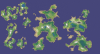
What tools should I be using to create these precise boundaries, whether delineated by natural features or imaginary lines? Apparently I could be using the path tool to do this but I...have no idea what that is, what it does, or how to use it, even after clicking and trying various things for several minutes. I've tried the quick selection/magic wand with various levels of tolerance, but it's still very rough in its selection and seemingly quite hard to modify without going pixel by pixel, since things like the coastal/beach lines, or spliced together continents of different internal colours tend to break up the regular shapes of landmasses, as you can see in the image.
On a minor note, it'd be nice if I could pattern certain areas with different opacity, because there are only so many easily distinguishable colours, so that red with stripes would be different from red with red, or red with crosses. I recall seeing some likely tools for this, but didn't try use them since I didn't have the basic overlays in place.
It doesn't need to be meticulous, I intend on later refining the entire map since it's obviously hacked together, but it's really hard to write relative locations if all you've got is 'Northern blob' and 'Southern blob', and I'm terrible at drawing so I'm pretty certain that anything I did draw would be more vague than in Photoshop. Having a state boundary end at the river boundary is fine, but when it suddenly extends hundreds of miles up through all that similarly coloured green area once that river dies inland, that is not ideal. I can't figure out how to manually do this without resorting to pixel by pixel. I'll do that if required, it's just, I've heard so many legends of Photoshop that I'm assuming this will all be very easy with the right tools and I won't have to resort to my standard tactic of doing things the most slow and basic way possible. I want the writing to take years, not the bloody map.
Any kind of help would be very much appreciated, since I have literally no idea what I'm doing or what I need to be looking for, thanks.
Basically, I'm starting a book project, and as a foundation I've cleaved together a basic continental map in paint, taken from a random generator, and now I'm trying to make some colour fills so one can easily distinguish between various states and regions, like a standard political map but with a bit less opacity, so landmarks and features can still be seen. I'm thinking that layering would be a good idea because there'll be different boundaries for different time periods, so from what I know of 'layers', being able to easily switch from one era to another seems pretty feasible, unless that's not what layers are for and I've been mislead by what English words mean in Photoshop.
I've asked a couple of people but gotten only vague suggestions, which led to me messing around with layers, selection tools, and rough paint fills. This was pretty unsuccessful and very messy.
What tools should I be using to create these precise boundaries, whether delineated by natural features or imaginary lines? Apparently I could be using the path tool to do this but I...have no idea what that is, what it does, or how to use it, even after clicking and trying various things for several minutes. I've tried the quick selection/magic wand with various levels of tolerance, but it's still very rough in its selection and seemingly quite hard to modify without going pixel by pixel, since things like the coastal/beach lines, or spliced together continents of different internal colours tend to break up the regular shapes of landmasses, as you can see in the image.
On a minor note, it'd be nice if I could pattern certain areas with different opacity, because there are only so many easily distinguishable colours, so that red with stripes would be different from red with red, or red with crosses. I recall seeing some likely tools for this, but didn't try use them since I didn't have the basic overlays in place.
It doesn't need to be meticulous, I intend on later refining the entire map since it's obviously hacked together, but it's really hard to write relative locations if all you've got is 'Northern blob' and 'Southern blob', and I'm terrible at drawing so I'm pretty certain that anything I did draw would be more vague than in Photoshop. Having a state boundary end at the river boundary is fine, but when it suddenly extends hundreds of miles up through all that similarly coloured green area once that river dies inland, that is not ideal. I can't figure out how to manually do this without resorting to pixel by pixel. I'll do that if required, it's just, I've heard so many legends of Photoshop that I'm assuming this will all be very easy with the right tools and I won't have to resort to my standard tactic of doing things the most slow and basic way possible. I want the writing to take years, not the bloody map.
Any kind of help would be very much appreciated, since I have literally no idea what I'm doing or what I need to be looking for, thanks.