What's new
Photoshop Gurus Forum

Welcome to Photoshop Gurus forum. Register a free account today to become a member! It's completely free. Once signed in, you'll enjoy an ad-free experience and be able to participate on this site by adding your own topics and posts, as well as connect with other members through your own private inbox!

Specific Need different map projection


Viceroy07

Member
Messages
9
Likes
1
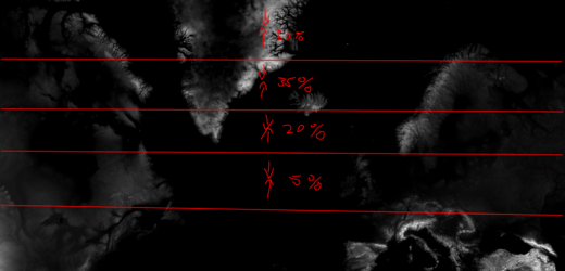
Hello, I need different map projection. Please shrink this heightmap gradually from top to bottom. Higher distortion on top, minimal on bottom. Due to this projection the landmasses up north are strectched. Does not have to be 100% accurate. The image in question is too big for upload so I am linking bellow a download link. Thanks!

image link: https://i.redd.it/5ksnesjhh7t91.png
 
To be more specific the map in the link is in mercator projection (area in higher latitude has higher inflation e.i. bigger) but I want something in winkel tripel projection (it's not perfect but does the job decently). For better idea you can check thetruesizeof website.
Also here is a screenshot what in theory it could look like on the image I posted above. The % is the estimate (I have done no calculations, this is meerly for demonstration) amount of shrinking.example.png
 
Hi @Viceroy07
This may not be what you want yet its a starting point. Its a transformation where the reduction in size is 50% at the top and 0% at the bottom in a linear fashion. You image is not quite linear so this my not be close enough.
The output below is two versions.
The first is the linear transformation with tone adjusted so the land masses can be seen better (at lest for other forum members)
The second is preserving your original tone.
The width was reduced down to 5000 wide to accommodate forum limits yet could provide a link with original sizes as well.
Kept in PNG format as well as untagged color profile

Here is the tone adjusted linear shrink.
mercator-to-winkel-tripel-projection-adj.png

Here is your original tone preserved with the linear shrink.
Hope these are helpful
John Wheeler

mercator-to-winkel-tripel-projection-adj-originall-tone.png
 
Hello, thank you for your reply, but sadly this is not quite it. Linear shrinking across the entire image wont change anything in terms of real size of landmasses. It need to be so the top part is shrunk more and from top down the shrinking decreases.
 
Hi @Viceroy07

Understand the message.
Here is a version that changes the latitudes to be of equal spacing which should match vertically what the winkel tripel projection is set to be. There is no horizontal adjustment so of course it is not a winkel tripel projection.
This should be closer to what you want. It would be very easy to scale the horizontal dimension by any fraction you desire if that is desired as well. If you desire a shrink horizontally, I could probably figure out the average amount for those latitudes for mercator to winkel tripel projection math.
John Wheeler

The full resolution images could be provided via a shared link if that is desired as well. Just did not want to do that unless this is what you want.

ADDED EDIT: By scaling just the vertical dimension in the image below, that type of projection is the same as in this link: https://www.srgbennett.com/blog/projections

mercator-to-winkel-tripel-projection--try2.png
 
Last edited:
Hi Viceroy
The changed projection is close to the original tone yet not exact. Partially because of the remapping to smaller number of pixels and also the approach I took for making the projection transformation. Hope that is good enough e.g. the histograms are not an exact match and indicates there is some slight posterization at the very low end of darkness. To avoid this we would need to start with a 16 bit image instead of 8 bit image.

Here is the final image with close to the original tone 5000 px wide below to fit in the forum limits for displaying .
I could not keep the exact full size image as I was using Adobe Camera Raw and it has a max size limit. It is therefore about 10,000 pixels wide instead of 11,000 pixels wide.
The near full resolution is at this link: Original tone new projection map

This is the best I can do with the approach I took and the time I can invest (which was more than I anticipate). There is another approach that could be used.
- convert the raster to a very high quality vector image (can be done automatically in Adobe Illustrator)
- Use this as input to ARCGIS software. ARCGIS software I believe can change mappings of projections much more easily that trying to do this in Photoshop. I no longer have ARCGIS and its been a long time since I have used it.

Hope this is helpful
John Wheeler

mercator-to-winkel-tripel-projection--tone-closer-to-original-PSgurus.png
 

Back
Top